High winds, humidity help Pack Trail Fire run seven miles in one day
By Wyoming News Exchange
October 7, 2024

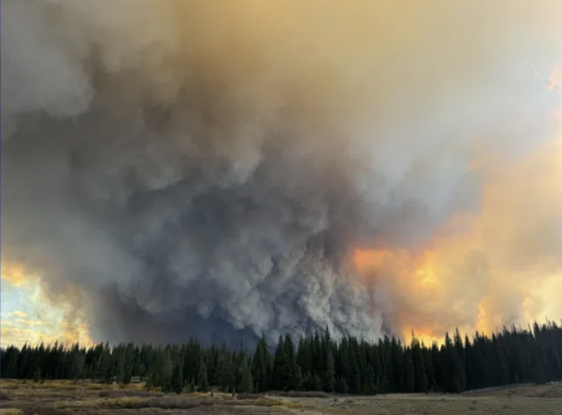
(Photo by Scott Crisp via Localnews8.com)
By Billy Arnold
Jackson Hole News&Guide
Via- Wyoming News Exchange
JACKSON — As high winds ripped through western Wyoming Friday night and Saturday, the Pack Trail Fire continued to expand east, closer to a road firefighters are using as a firebreak to protect Lava Mountain Lodge.
Overnight Friday, the newer Pack Trail Fire merged with its older cousin, the Fish Creek Fire. The two fires are being managed as one.
Together, they have burned well over 54,000 acres.
On Saturday, the Pack Trail Fire ran seven miles, chewing through timber on northerly slopes in the South Fork Fish Creek drainage.
That activity occurred along the fire’s southwestern flank, just across Burnt Ridge from ranches in the Gros Ventre River Basin.
As the crow flies, the western flank of the fire was approximately 2.5 miles east of the Elk Track ranches Sunday morning.
That subdivision, as well as the Goosewing Ranch and any other properties above the Goosewing Road junction, should be prepared to evacuate, officials said Saturday evening, placing them in the “Set” stage of the “Ready, Set, Go” evacuation framework.
Fire officials don’t necessarily expect the fire to reach the Upper Gros Ventre, but they want people in that area to be prepared.
“If they’re asked to leave, please leave,” said Melanie Banton, spokesperson for the California Interagency Incident Management Team 10, the U.S. Forest Service crew managing the fire.
“These fires can spot quite a ways ahead of themselves,” Banton said. “People look out their windows and the fire looks like it’s a couple miles away. And they look out again and it’s on their back step.”
In an emergency alert sent Sunday afternoon, Teton County Emergency Management Coordinator Rich Ochs said dry weather means the “Set” designation should stay in place for at least a week.
Upper Gros Ventre residents should be “prepared to evacuate at a moment’s notice during this time,” Ochs wrote. “We understand the anxiety this can cause and are working closely with the fire management team to lift the Set stage as soon as it is safe to do so.”
Going into the weekend, the National Weather Service issued a red flag warning, meaning that meteorologists were expecting high winds and low humidities that promote wildfire growth.
Overnight Friday, those predictions came true. Southwesterly winds hit 46 miles per hour on ridgetops and 24 mph in valleys. Still, the Pack Trail Fire only grew moderately overnight.
The most serious action happened Saturday, when winds started blowing out of the west, and gusted up to 60 mph.
As that happened, the air currents wrapped around Burnt Mountain on the west side of the fire, and blew out of the northwest into the South Fork Fish Creek drainage. That caused the fire’s seven mile run.
Its advance slowed near the Heifer Creek drainage.
In a Sunday morning briefing, Dan George, operations section chief for the Pack Trail Fire, said the firefighting crew had deployed firefighters to the Upper Gros Ventre drainage to scout the area.
“They’ll be out there for the next couple days,” George said.
Toward the east of the fire, Saturday’s westerly wind started pushing the blaze downhill to the U.S. Forest Service’s 540 Road around 1 a.m. Saturday. Fire crews are using that road, uphill and directly southwest of the Lava Mountain Lodge, as a firebreak. On Saturday, officials said a night shift of firefighters didn’t see many glows behind the lodge.
“It’s moderating,” George said Sunday morning. “We’re just not seeing that fire that we have been seeing over the last few days.”
George said structure protection crews have been sent to the area to ensure that if the fire crosses the 540 road, it’s kept out of the valley.
The fire team plans to run night shifts for a few more nights in the Highway 26 corridor to make sure the area is secure.
Over the next few days, winds are expected to moderate.
But Mark Loeffelbein, the fire’s meteorologist, is worried about low humidity. When the air is dry, it can “borrow” moisture from plants and other fuels like grasses and dead-and-down timber.
“It’ll dry them out, make them susceptible to fire, and that’s one of the problems we’re going to be having for the next few days,” Loeffelbein said in a Sunday morning weather update.
There is no moisture in the forecast, just small chances of precipitation on Tuesday and possibly Sunday. Without any rain or snow, the area’s relative humidity is expected to drop below 20% — the threshold below which dry air borrows moisture from plants.
By press time Sunday, residents of Brooks Lake Road, East and West Pinnacle Drive, Breccia Drive, plus anyone who lives along Togwotee Pass from mile post 30 to 42, remained under a mandatory evacuation order, the “Go” stage of the “Ready, Set, Go” evacuation framework.
This was true for residents of the Bourbon, Long Creek and Lava Mountain subdivisions, as well as the Triangle C Ranch and the old KOA.
Residents of the Union Pass Road and Absaroka Ranch Road were told to prepare for evacuation. They, like residents of the Upper Gros Ventre, are under the “Set” stage of the evacuation framework.

