Wyoming’s Red Canyon Fire balloons to over 107,000 acres amid evacuations, emergency order
By Wyoming News Exchange
August 19, 2025

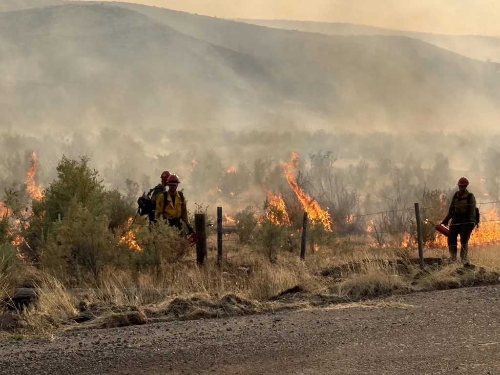
Photo: Firefighters perform burnout operations along Highway 172 east of Thermopolis. (Photo by Craig Cochran/InciWeb)
• Fire area now stretches from 11 miles east of Thermopolis to the borders of Fremont and Washakie counties. Large rural areas are under evacuation orders.
By Andrew Graham, WyoFile.com
A major wildland fire outside Thermopolis escalated significantly over the weekend, driving further evacuation warnings and an increasing federal response as the burn stretched from Hot Springs County to the borders of Fremont and Washakie counties.
The Red Canyon Fire began Aug. 13, and by Monday evening covered more than 107,000 acres — an area nearly the size of Denver — as strong winds and dry grass fueled its growth. The fire remains 11 miles east of Thermopolis, and evacuation orders so far appear limited to mostly rural areas. It is burning across ridges and creek drainages dominated by grassland and brush.
WyoFile has sought an estimate of the number of homes affected by the evacuation orders, but has so far not received one from official sources. There are “numerous structures threatened” after extreme fire behavior and large runs of flames driven by the wind over the weekend, the National Interagency Fire Center reported Monday.
The fire gained more than 20,000 acres Sunday into Monday, that agency reported. If evening estimates from the National Interagency Fire Center prove accurate, the fire had gained another 16,000 acres by 5 p.m. Monday, with more growth possible into the evening.
The areas under evacuation orders in Hot Springs County remain well to the east of the Bighorn River, which is lined by ranches, guesthouses, RV campgrounds and other businesses as it runs north out of Thermopolis toward Worland. On Monday, officials ordered the immediate evacuation of another sprawling rural zone south of the fire in Fremont County.
It was unclear if the fire itself had crossed the county line or remained in Hot Springs County, but officials warned of the possibility for flames to run down the drainage of Bridger Creek toward the community of Lysite.
Lysite itself was under an evacuation warning, but residents had not been asked to leave.
Most intense activity appeared to be on that southern front of the fire Monday. Firefighters on the northern end of the fire were conducting mop up operations and searching for hot spots — areas still smoldering after the main thrust of the flames had moved on or been extinguished.
Gov. Mark Gordon declared a state of emergency Monday, which allows him to bring the Wyoming National Guard into the response, if needed, and also gives the state access to some federal funding. The U.S. Federal Emergency Management Agency on Friday authorized federal funding to cover 75% of any state-level firefighting costs connected with the Red Canyon Fire.

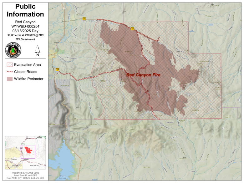
The Red Canyon Fire as of Aug. 18, 2025. (Graphic courtesy of InciWeb)
Also on Monday, a new federal team took over managing the fire, indicating its growing complexity — determined largely by fire size, weather and the number of homes and infrastructure threatened.
The Rocky Mountain Area Complex Incident Management Team 2 assumed command of the fire at 7 a.m. Monday, team public information officer Dakota Baker told WyoFile. Following days of high wind and worrying thunderstorms Sunday that could have brought other lightning-caused ignitions, officials Monday said they expected a very slight reprieve from an incoming high pressure system.
Structures and oil and gas infrastructure were all in the fire’s path, Baker told WyoFile on Monday morning, and firefighters were working to protect them. One major facility in the area of the fire’s southern flank was a natural gas processing plant near Lost Cabin.
The Lost Cabin plant processes a particularly sour mix of natural gas from dozens of conventional wells in the area, as well as 10 wells that reach 25,000 feet into the Madison formation (some of the deepest gas wells in the U.S.). The sour gas is laced with hydrogen sulfide, which is highly flammable and highly toxic. There’s an automated warning system that alerts motorists in the area, should there be a potential release.
Reached by WyoFile at 2:55 p.m. Monday, an employee at the Lost Cabin natural gas processing plant said they were not yet under orders to evacuate or shut down operations, but that they were on notice that an evacuation order could happen.
About 100 people were working on site at the time, and the fire was visible at a distance “near the mountains.”
There are two other significant fires burning in the Bighorn Basin, though they did not see the same level of growth as the Red Canyon Fire. The Spring Creek Fire near Ten Sleep is now at 3,575 acres, according to Washakie County Emergency Management, and crews under state management have made progress controlling it, working 24-hour shifts.
Firefighters were able to achieve even more containment of the Sleeper Ranch Fire, near Meeteetsee, which is currently estimated at 18,046 acres, according to the National Interagency Fire Center. That fire threatens sage grouse habitat and energy infrastructure.
Fires burn in mosaic patterns of intensity, and acreage measurements provided during ongoing fires do not mean the flames are burning across all that distance.
Officials reported portions of two area roads as closed due to the Red Canyon Fire: Buffalo Creek and Black Mountain roads. On Sunday and again on Monday, federal officials reported that some local residents were taking “independent actions” to protect their homes, and as a result, firefighters had to divert resources away from combatting the flames, though few details were provided.
“For firefighter safety and public safety, please avoid working in the fire area,” Monday’s update asked. Private drone flights had also been a problem, as they have been at an increasing number of fires nationwide in recent years. When people fly drones to document wildfires, it can ground the airborne water and fire retardant tankers, helicopters and other aircraft that are often critical to stemming flames’ rapid advance.
“If you fly, we can’t,” Monday’s statement read.
On Monday at 7 p.m., the incident management team and other state and local officials will gather for a community meeting at the Hot Springs County High School.
WyoFile staff writer Dustin Bleizeffer contributed reporting.
WyoFile is an independent nonprofit news organization focused on Wyoming people, places and policy.

